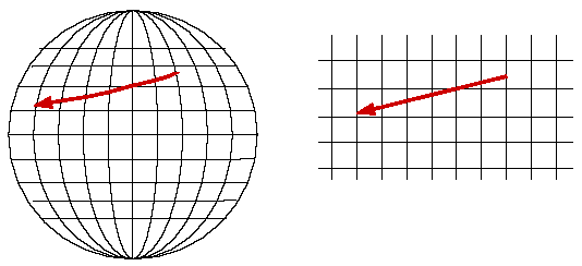
The rhumb line between two points on the earth's surface corresponds to the straight line on a Mercator chart.


Why does this work? The method relies on two properties of the Mercator projection. The first is well known to everyone: circles of latitude become horizontal lines on the map, and meridians become vertical lines. The second is more subtle: the Mercator projection is conformal. This means that angles on the map are the same as angles on the earth's surface. So since the compass course (by definition) always makes the same angle with the local meridian, it corresponds to the path on the Mercator map that meets each vertical at that same angle. In other words, a constant-course path must follow the rhumb line "track."